Fishermen remove a wooden structure from Bagdad beach, some 38 km (23.6 miles) from the border city of Matamoros, in anticipation of Tropical Storm Dolly July 22, 2008. Tropical Storm Dolly intensified over the warm waters of the western Gulf of Mexico as it bore down on southern Texas on Tuesday, but forecasters don't expect it to reach catastrophic strength before hitting land near the Mexican border on Wednesday.

Tourists walk along Bagdad beach, some 38 km (23.6 miles) from the border city of Matamoros July 22, 2008. Tropical Storm Dolly intensified over the warm waters of the western Gulf of Mexico as it bore down on southern Texas on Tuesday, but forecasters don't expect it to reach catastrophic strength before hitting land near the Mexican border on Wednesday.

Tourist walk along Bagdad beach, some 38 km (23.6 miles) from the border city of Matamoros July 22, 2008. Tropical Storm Dolly intensified over the warm waters of the western Gulf of Mexico as it bore down on southern Texas on Tuesday, but forecasters don't expect it to reach catastrophic strength before hitting land near the Mexican border on Wednesday.

A fisherman repairs a net at Bagdad beach, some 38 km (23.6 miles) from the border city of Matamoros July 22, 2008. Tropical Storm Dolly intensified over the warm waters of the western Gulf of Mexico as it bore down on southern Texas on Tuesday, but forecasters don't expect it to reach catastrophic strength before hitting land near the Mexican border on Wednesday.

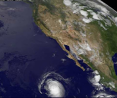
This image provided by NOAA taken at 4:45 EDT Thursday July 17, 2008 shows tropical storm Fausto. According to the National Hurricane Center in Miami, the storm had maximum sustained winds near 60 mph early Thursday. The storm is moving west near 16 mph and its center is located about 530 miles south of Manzanillo, Mexico.

This satellite image provided by NOAA shows Hurricane Bertha northeast of the island of Bermuda at about 12:04 p.m. EDT Tuesday July, 15, 2008. The hurricane was located about 260 miles northeast of Bermuda at 11:00 a.m. EDT with maximum sustained winds of around 70 miles per hour, according to NOAA.

In a photo provided by NASA, the MODIS instrument on NASAÕs Terra satellite captured this image on July 14, 2008. 11:05 a.m. EST of Tropical Storm Bertha in the Atlantic ocean. Bertha became the Atlantic season's first hurricane on July 7, but later weakened into a tropical storm. It is expected to re-strengthen into a hurricane on Tuesday,July 15, 2008, the National Hurricane Center said.

Tropical Storm Dolly is located off the Texas coast in this satellite image taken on July 22, 2008. Dolly intensified over the warm waters of the western Gulf of Mexico as it bore down on southern Texas on Tuesday, but forecasters don't expect it to reach catastrophic strength before hitting land near the Mexican border on Wednesday.

Tropical Storm Dolly is located southeast of Brownsville, Texas in this satellite image taken on July 22, 2008. Dolly intensified over the warm waters of the western Gulf of Mexico as it bore down on southern Texas on Tuesday, but forecasters don't expect it to reach catastrophic strength before hitting land near the Mexican border on Wednesday.

This image provided by NOAA shows Hurricane Bertha taken Thursday July 10, 2008 at 1:15 p.m. EDT. As of about 11 p.m. EDT Thursday, the center of the storm was about 385 miles southeast of Bermuda. Maximum sustained winds are about 85 mph with some higher gusting. The Atlantic season's first hurricane is traveling northwest at about 8 mph. Forecasters say Hurricane Bertha has weakened to a Category 1 storm and is moving slowly toward Bermuda, but could re-strengthen in the next 24 hours.

This natural-color image of Hurricane Bertha provided by NASA was captured by the Moderate Resolution Imaging Spectroradiometer on NASAÕs Terra satellite on Wednesday July 9, 2008, at 10:45 a.m. EDT. As of about 11 p.m. EDT Wednesday, the center of the storm was about 590 miles southeast of Bermuda. Maximum sustained winds are about 105 mph with some higher gusting. The storm is currently a Category 2

This image provided by NASA shows Hurricane Bertha taken by the Aqua satellite at 4 p.m. EDT Tuesday July 7, 2008. Forecasters say Hurricane Bertha has weakened to a Category 1 storm. As of 11 p.m. EDT Tuesday, the center of the storm was about 580 miles northeast of the northern Leeward Islands and about 840 miles southeast of Bermuda. Maximum sustained winds decreased to 80 mph with some higher gusting. The storm is expected to continue weakening over the next couple of days. Bertha is expected to continue heading toward Bermuda. It's unknown if or when the hurricane will make landfall.

This image provided by the NOAA is a false-color satellite view of Hurricane Bertha, right center, the first hurricane of the 2008 Atlantic season, at 5:45 a.m. EDT Monday July 7, 2008. Bertha is east of the nothern Leeward Islands and forcasters at the National Hurricane Center say it is too early to say if the storm will hit land.

This image provided by NOAA shows Tropical Storm Bertha taken at 7 p.m. EDT July 3, 2008. At 11 p.m. EDT Thursday, Bertha, The second named storm of the year, was centered 185 miles west-southwest of the southernmost Cape Verde Islands moving toward the west at about 14 mph, and forecasters expect that to continue for the next two days. Maximum sustained winds are near 45 mph. Some gradual strengthening was forecast during the next day or two. The first named storm this year, Arthur, formed in the Atlantic the day before the season officially started June 1 and soaked the Yucatan Peninsula.

No comments:
Post a Comment